
HIKES & EVENTS
Kaaterskill High Peak Hike
Hiking/Walk
DATE: Sep 07, 2014
END DATE: Sep 07, 2014
Hike/Event Location: Elka Park NY
Trip Leader(s)
shep5
Jaffrey, NH United States
Meeting Time: 9:00 AM
Max # People: 10
Hike Guiding / Event Fee: No, I will not be asking participants for money
Hike Difficulty Level:
Moderate
(Do you qualify to attend with this hike difficulty rating? Click Here.)
Sign Up To This Trip/Event
You must be a least a guest member to participate. Comments such as "+1" or "bringing a friend" are NOT permitted. All participants must sign-up for the event individually.
Select your mode of transportation, make any comments and then click on button.
You are not logged in.
Please, Log In
Summary
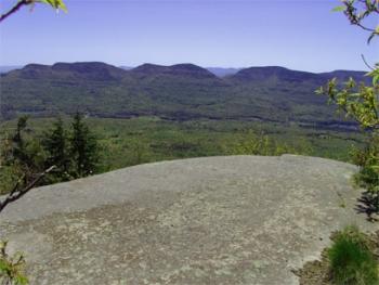
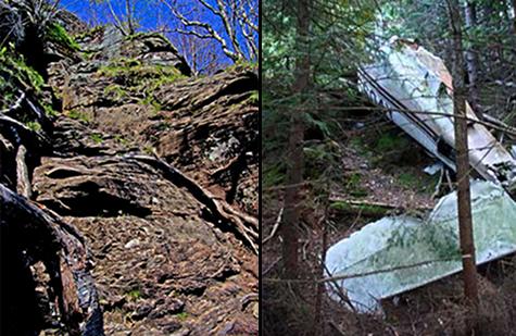
Join me for a mostly modest hike out to Kaaterskill High Peak (3655'). We'll use the southern approach from Platte Clove, as this is shorter with less elevation gain. Parts of the trail consist of a portion of the Long Path, snowmobile trails and unmaintained trails. To keep the distance to a reasonable level, we will bushwhack a very short distance between trails (0.2 miles)...this consists mostly of an old herd path through an old Mohawk Indian camp, which cuts out a few miles, so that we can traverse the summit from the south. Highlights of the hike include the summit, wonderful views from Hurricane Ledge near the summit and two airplane wrecks. Note: The trail grades are mostly gentle, with portions of level trail and a very steep section just below the summit on the southern flank.
Total Distance and Elevation Gain: 7.6-8.0 miles with approximately 1775 feet in elevation gain.
Optional extension: If there is interest, we can descend to the col with Round Mountain to see the "Hanging Ledge" and the site of an old Tory Fort (Fort Brant). This will add a couple of miles and will require some bushwhacking from the col back to the snowmobile trail.
Total Time: 6.0 to 7.0 hours depending on breaks and group's speed.
Rain or harsh weather may postpone to another date or cancel, as appropriate.
Camping Option: Contact me, if you're interested in camping Friday and/or Saturday night. I would be happy to set something up or provide details to share my site. I may be staying at the North-South Lake DEC Campground...contact me first.
What to Bring: Typical summer hiking gear should be appropriate: convertible hiking pants or shorts, good sturdy hiking boots with thick socks, a windbreaker/raingear. Note: Since we may bushwhack a short portion, hiking pants are highly recommended to protect your legs. Also bring along lunch, snacks and plenty of water (at least 2-L). Optionally, pack sunscreen, bug spray, and anything else that you may require for a day hike.
Carpooling: Contact other participants or the trip leader to arrange for a rideshare to the trailhead.
Afterwards: If there is sufficient interest, we will have drinks and/or dinner in the area (possibly at the Last Chance Restaurant/Bar in Tannersville or somewhere in Saugerties, depending on the direction that's convenient for everyone).
Directions To Trailhead Parking Lot
From the Thruway (I-87) take Exit 20 (Saugerties) for Route 212 West and follow for 2.3 miles. Take a slight right onto Blue Mountain Road (County Road 35) and follow for 1.4 miles. Turn left onto West Saugerties Road (County Road 33) and continue for another 3.0 miles. This will turn into Platte Clove Road, which will continue for another 1.3 miles (this is an unfinished seasonal road). The trailhead parking area will be off on the right...about 300 feet off the road. There should be a DEC sign, which may indicate the Huckleberry Point Trail/Long Path. This is about 20 minutes from the Thruway. Look for a gray Hyundai Elantra.
For GPS Users: 42.133801, -74.082036 with an approximate address of 2425 Platte Clove Rd, Elka Park, NY 12427.
Trip Leader

 Invite To Be Your Buddy
 Send Email
- Online Status: OFFLINE
- Last Login: 04/04/2020 12:45 PM
- Member Since: 10/30/2001
- Approved By: JPHiker
members signed up for this event

- Online Status: OFFLINE
- Last Login: 06/18/2023 07:28 AM
- Member Since: 04/18/2012
- Driving My Own Car
(Possibly willing to give guys a ride)
 |
 |
